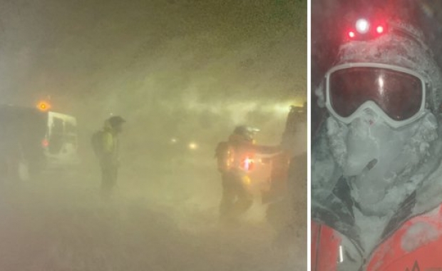

Travellers who are planning sightseeing trips tomorrow, Tuesday, should adjust their travel plans or prepare for a the worst, as a Yellow Weather Alert has been issued for all of Iceland, except the Eastfjords. A whole gale, with dangerously powerful windgusts, and heavy rain in parts of the country make for less than ideal travel conditions.
ICE-SAR has also issued travel alerts for tomorrow, asking travellers to show caution and slow down while driving. .
Read more: No injuries when bus carrying travellers on the Golden Circle tour rolled over on icy road
The weather alert is in effect from midnight until early morning on Wednesday.
Yellow Alert in effect

The Icelandic Meteorological Office is predicting full gale winds with isolated wind gusts which can pose danger to vehicles which catch wind. Travellers driving RVs, camper vans or cars pulling travel campers should show extreme caution or revise their travel plans.
Southeasterly winds with sustained windspeeds of 15-25 m/s (36-56 mph) with individual windgusts which can reach as much as 38 m/s (85 mph). The most dangerous winds can be expected in the vicinity of steep mountain sides.
The IMO urges travellers to be cautious.
Challenging driving conditions
ICE-SAR has issued travel warnings for South East Iceland and the entire South coast, including Jökulsárlón glacial lagoon, the Black Sand beaches near Vík and the Eyjafjöll mountains, where Seljalandsfoss and Skógafoss waterfalls are located. Heavy rain and swollen rivers are expected in south east Iceland between Vík and Breiðalsvík.
Travellers are also warned to expect strong winds along the south coast, as well as in the South West, including Reykjavík and the Reykjanes Peninsula where Keflavík airport is located. Strong wind, up to 35 m/s (78 mph). Drivers are urged to use caution and slow down.
ICE-SAR has also issued a travel alert for North Iceland, warning travellers to expect strong wind (up to 23m/s, 51mph) between Drangsnes and Þórshöfn in north Iceland, especially on mountain roads. Finally, travellers in the Eastfjords, Westfjords and North Iceland are warned of elevated avalanche Danger (level 3 of 5) in mountain areas in northern Westfjords, Tröllaskagi Peninsula and in the Eastfjords.