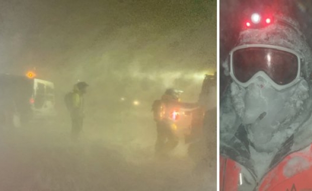

If you were planning to head out on the road tonight, Thursday, or tomorrow morning, Friday, you might want to revise your travel plans. Yellow and orange weather alerts have been issued for all of Iceland, except the South East. Severe gale, and heavy rain or snow will create dangerous driving conditions, especially near mountains.
No travel weather

The Icelandic Meteorological Office has issued a Yellow Weather alert, effective from noon today from 21:00 (9 pm) tonight for West Iceland, including the capital region, and 22:00 (10 pm) for South Iceland effective until 9-11 tomorrow morning. Severe gale with rain and thawing snow and ice, creating dangerously slippery conditions on roads.
An orange weather alert has also been issued for the Westfjords from 23:00 and North West Iceland, from midnight, until 11:30-13:30 tomorrow. Severe gale and storm with snow and sleet will create dangerously violent winds and low visibility.
The IMO warns that while windspeeds will average 18-23 m/s (40-51 mph) gusts and localized winds, especially near mountains or on heaths, can easily exceed 40 m/s (90 mph). Hurricane force winds (windspeeds in excess of 45 m/s, 100 mph), can be expected.
Travellers should remember keep two things in mind:
1) Expect powerful windgusts when driving near steep mountain sides. Individual gusts can easily reach hurricane force, causing drivers to lose control of their vehicles or blowing cars off the road. The Ring Road runs close to numerous steep mountains where such windgusts form.
2) Driving conditions become progressively more difficult at higher altitudes. The Ring Road crosses several mountain passes and heaths where driving conditions can deteriorate rapidly.
ICE-SAR travel alert
ICE-SAR has also issued travel alerts, asking travellers to take care on the Ring Road between Reykjavík and the town of Borgarnes in West Iceland.
Gusts over 45 m/s (100 mph, 165 km/h) expected tonight from 21:00 near mountains, Reykjavík to Borgarnes and on N-Snæfellsnes peninsula until tomorrow morning! Poor visibility and icy roads! Avoid travel at this time!
People are also asked to avoid travel in NW-Iceland:
Gusts over 40 m/s (90 mph, 145 km/h) and snow expected on mountain roads from Borgarnes to Varmahlíð and from Hólmavík to Ísafjörður in Westfjords tonight until tomorrow noon. Avoid travel at this time!
ICE-SAR has also issued a travel warning for for tonight:
Night storm 01.-02.02.18! NO TRAVEL CONDITION in almost all Iceland, starting tonight at 20:00 in west and ending in east tomorrow afternoon, Friday! See other alerts for more detail!