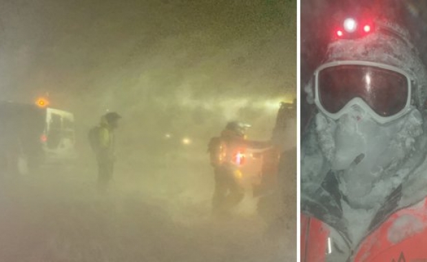

The Icelandic Meteorological Office is predicting a severe storm will hit South Iceland this afternoon and then pass over all of Iceland tonight. The wind is expected to reach as much as 44 metres per second, (98 mph/160 km per hour) along the south coast. Hurricanes are defined as storms with wind speeds in excess of 32 metres per second.
The Icelandic meteorological office warns that storms of this strength are seen once every ten to twenty years.
Winds will pick up during the day
According to the Icelandic Met Office winds have been picking up in South Iceland, with increasingly strong gusts from the East. The winds are expected to bring some snow in South East Iceland, but no precipitation is expected in other parts of the country. By noon the winds in South Iceland are expected to have reached the strength of strong gale and storm. The winds are expected to bring with them heavy snows and blowing snow.
Severe storm warning for the afternoon and evening
As the winds pick up the temperature is expected to rise. By tonight the storm is expected to have engulfed all of Iceland with snow and sleet, as well as heavy rain in East Iceland. Temperatures along the coast are expected to be 1-7°C (33.8°-48.2°F).
The weather will begin to calm down in North and East Iceland during the night, but severe weather conditions are expected to remain in South, with heavy rain.
Tomorrow strong winds and rain or sleet can be expected around Iceland, although temperatures will begin to drop in the north, accompanied with renewed snows.
Dangerous road conditions
Conditions along the ring road near Vík in South Iceland are expected to have become dangerous by 14:00-16:00. The Icelandic Road and Coastal administration also warns that most all roads in South Iceland are slippery due to icing. Shortly thereafter motorists on the ring road north of Reykjavík and the road to Keflavík will begin to experience heavy blowing snow with little or no visibility.
People are advised to stay inside and not venture out onto the roads. All domestic flights have been cancelled in the afternoon, and the metropolitan bus service has announced it expects severe disruptions to its service.
Due to the weather Search and Rescue teams warn they might not be able to respond to all calls. A spokesperson for Iceland Search and Rescue told the local news site visir.is that people who are not driving well prepared vehicles, with four wheel drive, should under no circumstancesbe out driving in the afternoon. She also warns that the wind can break car windows, and when combined with slippery road conditions, blow cars off the road.
People are also asked to warn foreign travellers who might not have gotten the weather warning to stay off the roads today.