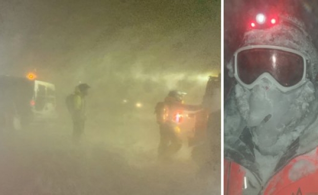


Looks like we're in for another stormy, wet weekend!
Heavy rain is expected in the south and southeast regions this afternoon and will continue through the weekend. The Icelandic Met Office warns of possible flooding following the heavy rainfall along with melting ice and snow. A strong gale wind, measuring more than 20 metres per second (45 mph/72 km/h), is expected today, at first in the west and south coast but will move to the east by evening. Winds will pick up tomorrow, Saturday, reaching a speed of more than 30 metres per second (67 mph/108 km/h).
Read more: The winter of relentless string of storms: number 38 will hit today
Road conditions:
The heavy rain, strong winds, and possible flooding will cause terrible travel conditions during the weekend. Drivers are warned not to travel between regions today or tomorrow.
There are slick road conditions today on Route 1 across Hellisheiði and in many parts of South Iceland.
Icy patches are reported on roads on the west coast and snow drift on the roads across Brattabrekka and Holtavörðuheiði.
The Þröskuldar and Kleifarheiði roads in the Westfjords are currently impassable due to snow. Icy patches are reported on roads in North and East Iceland, while Fjarðarheiði mountain road is extremely slick.

Read more: Heavy rain in the south coast tomorrow afternoon can cause flooding and mudslides
The weather forecast for this weekend:
Saturday: A violent storm will hit most parts of the country, with blasts of winds measuring more than 30 metres per second (67 mph/108 km/h). Winds are expected to decrease by afternoon. Considerable rain in the south, but remaining mostly dry in the north with occasional spells of rain. Rising temperatures.
Sunday: Becoming warmer with a southerly breeze. Winds are expected to pick up in the afternoon accompanied with considerable rain in the southeast. Other parts of the country will experience rain and sleet, while snowfall is expected in the north. Maximum temperature 10 degrees Celsius (50 Fahrenheit).
Monday: Strong southerly winds accompanied with rain or sleet but drier conditions in the north. Winds will decrease by afternoon. Maximum temperature 7 degrees Celsius (45 Fahrenheit).
Looks like we're in for another stormy, wet weekend!
Heavy rain is expected in the south and southeast regions this afternoon and will continue through the weekend. The Icelandic Met Office warns of possible flooding following the heavy rainfall along with melting ice and snow. A strong gale wind, measuring more than 20 metres per second (45 mph/72 km/h), is expected today, at first in the west and south coast but will move to the east by evening. Winds will pick up tomorrow, Saturday, reaching a speed of more than 30 metres per second (67 mph/108 km/h).
Read more: The winter of relentless string of storms: number 38 will hit today
Road conditions:
The heavy rain, strong winds, and possible flooding will cause terrible travel conditions during the weekend. Drivers are warned not to travel between regions today or tomorrow.
There are slick road conditions today on Route 1 across Hellisheiði and in many parts of South Iceland.
Icy patches are reported on roads on the west coast and snow drift on the roads across Brattabrekka and Holtavörðuheiði.
The Þröskuldar and Kleifarheiði roads in the Westfjords are currently impassable due to snow. Icy patches are reported on roads in North and East Iceland, while Fjarðarheiði mountain road is extremely slick.
Read more: Heavy rain in the south coast tomorrow afternoon can cause flooding and mudslides
The weather forecast for this weekend:
Saturday: A violent storm will hit most parts of the country, with blasts of winds measuring more than 30 metres per second (67 mph/108 km/h). Winds are expected to decrease by afternoon. Considerable rain in the south, but remaining mostly dry in the north with occasional spells of rain. Rising temperatures.
Sunday: Becoming warmer with a southerly breeze. Winds are expected to pick up in the afternoon accompanied with considerable rain in the southeast. Other parts of the country will experience rain and sleet, while snowfall is expected in the north. Maximum temperature 10 degrees Celsius (50 Fahrenheit).
Monday: Strong southerly winds accompanied with rain or sleet but drier conditions in the north. Winds will decrease by afternoon. Maximum temperature 7 degrees Celsius (45 Fahrenheit).