The powers which created Iceland and continue to shape its geography were on full display over the weekend as a powerful earthquake swarm shook Þingvellir National Park, one of Iceland‘s most spectacular natural monuments. The earthquake swarm was felt in the National Park and as far as the suburbs of Reykjavík and parts of South Iceland.
112 quakes

The seismic monitoring system of the Icelandic Meteorological Office detected 66 quakes in the mountain on Saturday and more than 50 on Sunday. A total of 116 quakes have been detected since Saturday morning when the swarm began.
The swarm has included several relatively large quakes, measuring more than 3 on the Richter scale. Quakes of this magnitude have not been detected in the mountain since 1992.
A 3.5 magnitude quake was detected at 19:20 on Saturday evening, followed by a second 3.1 magnitude quake at 19:58 and a 3.7 magnitude quake at 21:25. A fourth larger quake, 3.8 on the Richter scale, was then detected at 8:48 on Sunday morning.
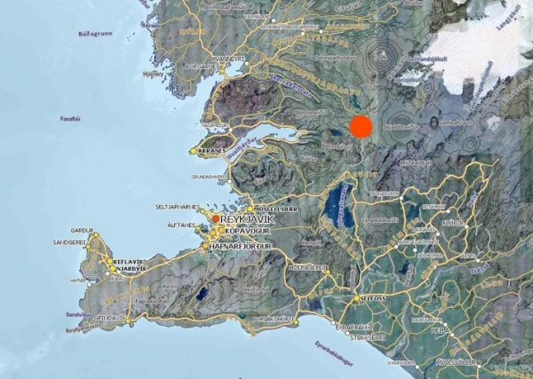
The epicenter of the activity has been in the east-northeaster slopes of mount Skjaldbreiður at a depth of of 5-6 km (3.1-3.7 miles.) The activity appears to be subsiding, the IMO reports.
No volcanic activity

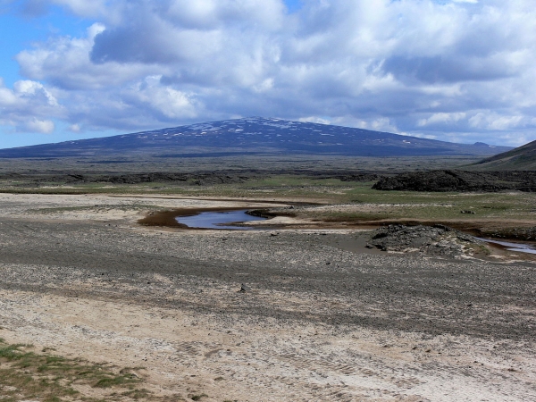
Skjaldbreiður is a giant shield volcano rising 1,060 m (3,480 ft) above sea level. The crater is roughly 300 m (990 ft) in diameter. Skjaldbreiður was formed 9000 years ago, after the last ice age glaciers melted, in one giant eruption which is believed to have lasted decades. Skjaldbreiður is part of the larger Langjökull system. The latest eruption in the system took place in the year 900. This eruption, which took place north of Langjökull glacier, produced a giant lava filed Hallmundarhraun which contains several large caves.
Read more: Visitors Flock to Víðgelmir Lava Cave
Any earthquake larger than 3 on the Richter scale in a volcano is considered to be a significant seismic event. The quakes over the weekend are not believed to be caused by volcanic activity.
Read more: Why the constant earthquakes? Iceland is slowly being torn apart

Seismologists at the IMO believe the quakes are caused by the release of tension which builds up as the continental plates drift in opposite directions. Þingvellir National Park is located in a rift valley created by the drifting apart of the plates. Seismic activity is therefore very common in Þingvellir. Last year a powerful swarm took place at the southern edge of the lake.
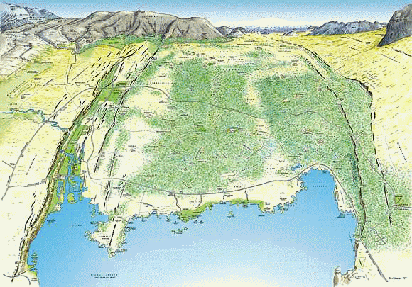
The rift valley which contains Þingvellir and Þingvallavatn lake is clearly visible to visitors who stand on the edge of Almannagjá canyon on the western edge of the valley: A visitor who stands on top of the cliff is in effect standing on the North American Continental Plate. The canyons on the eastern edge of the valley mark the edge of the Eurasian Continental Plate.
As the plates drift apart by 2cm (0.8 in) annually, the valley between the plates subsides. Periodically the volcanic system to the north and east of Þingvellir erupts, covering the valley with fresh lava.
The powers which created Iceland and continue to shape its geography were on full display over the weekend as a powerful earthquake swarm shook Þingvellir National Park, one of Iceland‘s most spectacular natural monuments. The earthquake swarm was felt in the National Park and as far as the suburbs of Reykjavík and parts of South Iceland.
112 quakes

The seismic monitoring system of the Icelandic Meteorological Office detected 66 quakes in the mountain on Saturday and more than 50 on Sunday. A total of 116 quakes have been detected since Saturday morning when the swarm began.
The swarm has included several relatively large quakes, measuring more than 3 on the Richter scale. Quakes of this magnitude have not been detected in the mountain since 1992.
A 3.5 magnitude quake was detected at 19:20 on Saturday evening, followed by a second 3.1 magnitude quake at 19:58 and a 3.7 magnitude quake at 21:25. A fourth larger quake, 3.8 on the Richter scale, was then detected at 8:48 on Sunday morning.
The epicenter of the activity has been in the east-northeaster slopes of mount Skjaldbreiður at a depth of of 5-6 km (3.1-3.7 miles.) The activity appears to be subsiding, the IMO reports.
No volcanic activity

Skjaldbreiður is a giant shield volcano rising 1,060 m (3,480 ft) above sea level. The crater is roughly 300 m (990 ft) in diameter. Skjaldbreiður was formed 9000 years ago, after the last ice age glaciers melted, in one giant eruption which is believed to have lasted decades. Skjaldbreiður is part of the larger Langjökull system. The latest eruption in the system took place in the year 900. This eruption, which took place north of Langjökull glacier, produced a giant lava filed Hallmundarhraun which contains several large caves.
Read more: Visitors Flock to Víðgelmir Lava Cave
Any earthquake larger than 3 on the Richter scale in a volcano is considered to be a significant seismic event. The quakes over the weekend are not believed to be caused by volcanic activity.
Read more: Why the constant earthquakes? Iceland is slowly being torn apart

Seismologists at the IMO believe the quakes are caused by the release of tension which builds up as the continental plates drift in opposite directions. Þingvellir National Park is located in a rift valley created by the drifting apart of the plates. Seismic activity is therefore very common in Þingvellir. Last year a powerful swarm took place at the southern edge of the lake.
The rift valley which contains Þingvellir and Þingvallavatn lake is clearly visible to visitors who stand on the edge of Almannagjá canyon on the western edge of the valley: A visitor who stands on top of the cliff is in effect standing on the North American Continental Plate. The canyons on the eastern edge of the valley mark the edge of the Eurasian Continental Plate.
As the plates drift apart by 2cm (0.8 in) annually, the valley between the plates subsides. Periodically the volcanic system to the north and east of Þingvellir erupts, covering the valley with fresh lava.


