In an average week Iceland's national monitoring seismic network detects around 500 earthquakes. Now and again this number can be much higher when an earthquake swarm hits one or more of Iceland's many volcanoes.
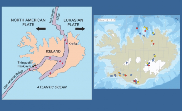
The reason for this seismic activity is Iceland's location right on the divergent boundary between the Eurasian plate and the North American plate. Iceland is in effect slowly splitting apart along the spreading center between the plates, with the North America plate moving westward from the Eurasia plate. The rate of spreading along the Mid-Atlantic Ridge averages about 2.5 centimeters (1 inch) per year, or 25 kilometers (15.5 miles) in a million years.
As you can see on the maps above the earthquakes occur directly along the boundary between the plates. The map to the right shows earthquakes that have been recorded in the last 48 hours.

Most of the earthquakes hits without people noticing them. They don't affect daily life except when they might be a sign of an impending eruption, as happened this autumn when an earthquake swarm hit the huge Katla sub-glacial volcano, and police evacuated and closed access to nearby travel destinations.
At Þingvellir National Park, in South Iceland, you can however see clearly with your own eyes how these forces of nature are shaping Iceland's landscape. The cracks, faults and canyons which traverse the region are signs of the continental drift between the North American and Eurasian Plates. Pictured to the right is the largest one, Almannagjá canyon.
The location on the tip of the Reykjanes Peninsula is the only place in the world where you can see the Mid-Atlantic ridge rise above sea level. Close by you can walk over The Bridge Between Continents. Yes, it's a little bit of a gimmicky concept but this is indeed a location where the tectonic plates are drifting apart from each other. The bridge is located About 7km south of Hafnir by road 425.
Read more: Earthquakes in Reykjanes peninsula continue, felt in the capital area
The national monitoring seismic network
The Icelandic Met Office's automatic monitoring network has been in operation for two decades. Besides evaluating source function and mechanism information carried from below by micro-earthquakes, it provides near real-time information that is used as the basis for an alert system.
In an average week Iceland's national monitoring seismic network detects around 500 earthquakes. Now and again this number can be much higher when an earthquake swarm hits one or more of Iceland's many volcanoes.
The reason for this seismic activity is Iceland's location right on the divergent boundary between the Eurasian plate and the North American plate. Iceland is in effect slowly splitting apart along the spreading center between the plates, with the North America plate moving westward from the Eurasia plate. The rate of spreading along the Mid-Atlantic Ridge averages about 2.5 centimeters (1 inch) per year, or 25 kilometers (15.5 miles) in a million years.
As you can see on the maps above the earthquakes occur directly along the boundary between the plates. The map to the right shows earthquakes that have been recorded in the last 48 hours.

Most of the earthquakes hits without people noticing them. They don't affect daily life except when they might be a sign of an impending eruption, as happened this autumn when an earthquake swarm hit the huge Katla sub-glacial volcano, and police evacuated and closed access to nearby travel destinations.
At Þingvellir National Park, in South Iceland, you can however see clearly with your own eyes how these forces of nature are shaping Iceland's landscape. The cracks, faults and canyons which traverse the region are signs of the continental drift between the North American and Eurasian Plates. Pictured to the right is the largest one, Almannagjá canyon.
The location on the tip of the Reykjanes Peninsula is the only place in the world where you can see the Mid-Atlantic ridge rise above sea level. Close by you can walk over The Bridge Between Continents. Yes, it's a little bit of a gimmicky concept but this is indeed a location where the tectonic plates are drifting apart from each other. The bridge is located About 7km south of Hafnir by road 425.
Read more: Earthquakes in Reykjanes peninsula continue, felt in the capital area
The national monitoring seismic network
The Icelandic Met Office's automatic monitoring network has been in operation for two decades. Besides evaluating source function and mechanism information carried from below by micro-earthquakes, it provides near real-time information that is used as the basis for an alert system.


