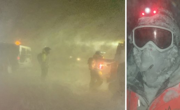


Travellers are encouraged to keep close track of the weather and to consider re-scheduling any major trips tomorrow due to a storm which will hit parts of South, Southwest and West Iceland later tonight. The Icelandic Meteorological Office warns that the weather forecast for the next few days suggests travel, whether by domestic flight or road, can easily be disrupted tonight and tomorrow.
Storm and rain or sleet in S. and W. Iceland by tonight
The IMO expectes a southerly wind, growing from a fresh breeze to full whole gale or storm by tonight. The wind speeds are expected to remain 8-15 m/s (18-34 mph) today but will have reached 15-23 m/s (34-51 mph) by tonight. Temperature will remain 1-5°C (34-41°F) today, mostly dry but rising to 3-9°C (37-48°F) with rain or sleet tonight.
Colder temperatures, snowshowers and gale force winds
Tomorrow the winds will remain at gale force, between 13-20 m/s (29-45 mph), from the south west. The temperature will drop by the afternoon to freezing, causing icing on roads coupled with high winds. The IMO warns that driving conditions tomorrow might become challenging.
Travellers are advised to check the weather forecast at the website of the Icelandic Meteorological Office, and to show caution, especially when driving along mountain sides where powerful wind gusts can form. Icy roads and strong winds can easily cause motorists to lose control of their vehicles. The Marlow, or non-existing shoulders on Icelandic roads can turn even a momentary loss of control into a roll-over.
And, remember: Buckle up!