River levels will continue to rise in Southern Iceland until midnight on Friday according to The Icelandic Met Office (IMO) which also warns that the heavy rain, which is continuing in South Iceland, increases the likelihood of landslides.
Localised flooding is likely and small streams on hiking routes will become impassable. IMO urges travellers to avoid all watercourses in the coming days in those regions where flooding is occurring:
Barðaströnd, which the coastline between Vatnsfjörður fjord and Sigluneshlíðar cliff in the southern Westfjords region.
Snæfellsness peninsula in West Iceland
From Mýrdalsjökull glacier to Hornafjörður fjord in South Iceland. Note that river levels around Mýrdalsjökull will increase further today.
According to IMO most rivers will take days to return to pre-flood conditions, so keep this in mind when making travel plans.
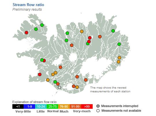
 Stream flow ratio Image by The Iceland Met Office
IMO reports that the discharge of glacial rivers Múlakvísl and Jökulsá á Sólheimsandi beach is high due to sustained rainfall. Both rivers are at levels seen only during outburst floods in recent decades. Glacial river Krossá in Þórsmörk nature reserve is exceptionally high, resulting in widespread inundation of the valley. Note that river levels around Mýrdalsjökull glacier will increase further on Thursday.
Rivers to the east of Mýrdalsjökull have risen rapidly as the rainfall intensified in the region. Flood conditions are expected in streams and rivers from Mýrdalsjökull to Hornafjörður fjord. Djúpá river, located west of Skeiðarársandur beach, has reached a discharge of 100 m³/s and the river will swell markedly on Thursday.
According to IMO such prolonged, intense rainfall is extreme, even by Icelandic standards.
Read more: Warning: Heavy rain in South Iceland and strong gales expected in the highlands
River levels will continue to rise in Southern Iceland until midnight on Friday according to The Icelandic Met Office (IMO) which also warns that the heavy rain, which is continuing in South Iceland, increases the likelihood of landslides.
Localised flooding is likely and small streams on hiking routes will become impassable. IMO urges travellers to avoid all watercourses in the coming days in those regions where flooding is occurring:
Barðaströnd, which the coastline between Vatnsfjörður fjord and Sigluneshlíðar cliff in the southern Westfjords region.
Snæfellsness peninsula in West Iceland
From Mýrdalsjökull glacier to Hornafjörður fjord in South Iceland. Note that river levels around Mýrdalsjökull will increase further today.
According to IMO most rivers will take days to return to pre-flood conditions, so keep this in mind when making travel plans.
 Stream flow ratio Image by The Iceland Met Office
IMO reports that the discharge of glacial rivers Múlakvísl and Jökulsá á Sólheimsandi beach is high due to sustained rainfall. Both rivers are at levels seen only during outburst floods in recent decades. Glacial river Krossá in Þórsmörk nature reserve is exceptionally high, resulting in widespread inundation of the valley. Note that river levels around Mýrdalsjökull glacier will increase further on Thursday.
Rivers to the east of Mýrdalsjökull have risen rapidly as the rainfall intensified in the region. Flood conditions are expected in streams and rivers from Mýrdalsjökull to Hornafjörður fjord. Djúpá river, located west of Skeiðarársandur beach, has reached a discharge of 100 m³/s and the river will swell markedly on Thursday.
According to IMO such prolonged, intense rainfall is extreme, even by Icelandic standards.
Read more: Warning: Heavy rain in South Iceland and strong gales expected in the highlands


