The earth has been trembling in the town of Selfoss, the largest town in South Iceland, since yesterday evening when a sharp earthquake swarm began in the South Iceland fracture zone. The swarm seems to be dying down, although dozens of aftershocks have been detected.
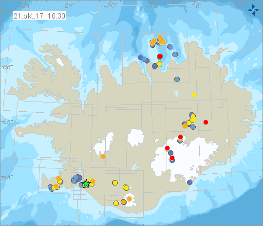
South Iceland seismic zone
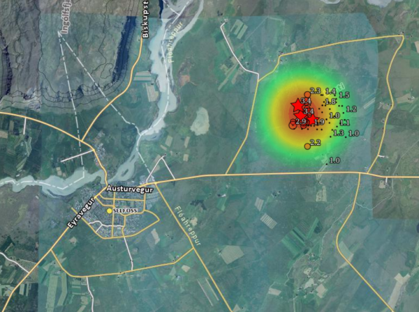
The seismic monitoring system of the Icelandic Meteorological Service has counted more than 160 quakes in the swarm, most relatively small. The most powerful quake, a 3.4 magnitude tremor, was felt clearly in Selfoss, as it's epicenter was only 6.6 km 4.1 mi) north-east of the town, and was even felt in Reykjavík. Houses in Selfoss trembled, but no damage has been reported.
Seosmologists at the Icelandic Meteorological Office say the quakes are caused by the release of friction which builds up by the drifting of the tectonic plates. Iceland sits atop the North Atlantic Ridge, where the plates drift in opposite direction at the rate of 2cm (0.8 in) annually.
An area known for high seismic activity

A rift zone runs through South Iceland is known for powerful earthquakes. This South Iceland Seismic Zone connectes the two volcanic zones which run through Iceland. The Eastern and Western Volcanic Zones form part of the North Atlantic Ridge. All of Iceland's most active volcanoes and geothermal areas are located in these zones, and they are known for high and regular seismic activity, caused by energy being released as the tectonic plates drift in opposite directions from one another.
The most powerful quake in South Iceland is a 1784 massive earthquake which is believed to have been 7.1 magnitude quake.
Swarm seems to be dying down
The seismic activity began yesterday evening at 20:40 yesterday evening with a 2.9 magnitude tremor which was felt very clearly in the town. A second more powerful 3.4 magnitude quake then hit at 21:51, followed by dozens of smaller tremors. The activity seems to be slowing down, although dozens of quakes have been felt this morning.
Read more: Why the constant earthquakes? Iceland is slowly being torn apart
The epicenters of all the quakes have been north east of the town near a crevice which was formed either in the 1784 earthquake, or an earlier quake in 1734. The epicenters of the quakes have been at a significant depth of 2-3 km (1.2-2.5 mi). In Iceland earthquakes closer to the surface are more common in volcanic systems, caused by the movement of magma, while deeper quakes are more common in fracture zones, caused by the release of energy caused by the movement of the tectonic plates.

The earth has been trembling in the town of Selfoss, the largest town in South Iceland, since yesterday evening when a sharp earthquake swarm began in the South Iceland fracture zone. The swarm seems to be dying down, although dozens of aftershocks have been detected.
South Iceland seismic zone
The seismic monitoring system of the Icelandic Meteorological Service has counted more than 160 quakes in the swarm, most relatively small. The most powerful quake, a 3.4 magnitude tremor, was felt clearly in Selfoss, as it's epicenter was only 6.6 km 4.1 mi) north-east of the town, and was even felt in Reykjavík. Houses in Selfoss trembled, but no damage has been reported.
Seosmologists at the Icelandic Meteorological Office say the quakes are caused by the release of friction which builds up by the drifting of the tectonic plates. Iceland sits atop the North Atlantic Ridge, where the plates drift in opposite direction at the rate of 2cm (0.8 in) annually.
An area known for high seismic activity

A rift zone runs through South Iceland is known for powerful earthquakes. This South Iceland Seismic Zone connectes the two volcanic zones which run through Iceland. The Eastern and Western Volcanic Zones form part of the North Atlantic Ridge. All of Iceland's most active volcanoes and geothermal areas are located in these zones, and they are known for high and regular seismic activity, caused by energy being released as the tectonic plates drift in opposite directions from one another.
The most powerful quake in South Iceland is a 1784 massive earthquake which is believed to have been 7.1 magnitude quake.
Swarm seems to be dying down
The seismic activity began yesterday evening at 20:40 yesterday evening with a 2.9 magnitude tremor which was felt very clearly in the town. A second more powerful 3.4 magnitude quake then hit at 21:51, followed by dozens of smaller tremors. The activity seems to be slowing down, although dozens of quakes have been felt this morning.
Read more: Why the constant earthquakes? Iceland is slowly being torn apart
The epicenters of all the quakes have been north east of the town near a crevice which was formed either in the 1784 earthquake, or an earlier quake in 1734. The epicenters of the quakes have been at a significant depth of 2-3 km (1.2-2.5 mi). In Iceland earthquakes closer to the surface are more common in volcanic systems, caused by the movement of magma, while deeper quakes are more common in fracture zones, caused by the release of energy caused by the movement of the tectonic plates.


