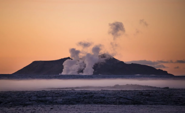

The seismic activity off the north coast of Iceland continued this morning, with a sharp quake west of Kolbeinsey islet, the northernmost point of Iceland. The activity, which began late last week with a powerful earthquake swarm around Grímsey Island, is showing signs of decreasing, although a couple of dozen smaller tremors have been detected around Grímsey since Saturday.
Read more: Why the constant earthquakes? Iceland is slowly being torn apart
The Icelandic Meteorological Office reports that the magnitude 3.1 quake had an epicenter 5.9 km north-northwest of Kolbeinsey islet at a depth of 8.7 km.
Read more: Four powerful earthquakes since yesterday: Iceland's most isolated village, Grímsey island, trembles
Last week's quakes around Grímsey all originated at similar depths, as can be expected when earthquakes are caused by the release of energy from tensions which build up as the crust is pulled apart when the tectonic plates drift in opposite directions. Kolbeinsey and Grímsey are both located on the North Atlantic ridge where it extends north of Iceland.

A tiny islet destined to disappear
Kolbeinsey islet, which is located 105 km (65 mi) north off the north coast of Iceland and 74 km (46 mi) north-west of Grímsey island, Iceland's northernmost settlement, is the northernmost point of Iceland. It is known to English sailors as Seagull Rock.
The islet is located on the Tjörnesbrotabeltið part of the North Atlantic Ridge, a site of intense seismic and volcanic activity. Kolbeinsey is the remnants of a volcanic island which formed in an submarine eruption ca 12,000 years ago. Since then the basalt rock of the islet has been subject to the intense erosion of the North Atlantic.
The original size of the island is unknown, but it would have been significantly larger than it is today. Currently the islet is little more than a skerry, and it is projected to disappear completely within a few years. When the island was first measured in the early 17th century it was 700 m (2,300 ft) from north to south and 100 m (330 ft) east to west. Today it is just 90 sq m (970 sq ft), rising just 8 m above the sea.