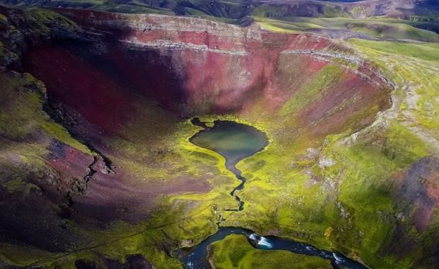

One of the amazing destinations in the Fjalllabak region is Rauðibotn crater: A red and green emerald surrounded by the volcanic deserts and wastelands between Torfajökull and Mýrdalsjökull glaciers. A hike to Rauðibotn is made all the more spectacular by the river Hólmsá and its waterfalls, which form a spectacular string of pearls.
Forged in Ragnarrök
Rauðibotn is part of the Eldgjá craters, a chain of volcanic craters which stretches through the Central Highlands from Mýrdalsjökull glacier to Vatnajökull glacier. Eldgjá is connected to the monster volcano Katla, as both are part of the same volcanic system. Eldgjá has only erupted once since the VIking settlement of Iceland in the 9th century: In 934 a massive eruption, believed to be the largest volcanic eruption to take place in Iceland in the past millennia.
The 934 eruption produced a lava field which covers approximately 800 square kilometers (310 square miles), 18 cubic kilometers (4.3 cubic miles) of lava and 5-7 cubic kilometers (1.2-1.7 cubic miles) of tephra and ash. The size of the lava field is large enough to cover all of New York City, and then some. The impact of the eruption on global weather systems was catastrophic, causing crop failures and hunger in Europe. Temperatures all over the Northern Hemisphere dropped, causing rivers as far as present day Iran to have frozen over.
The giant eruption is believed to have inspired the descriptions of Ragnarrök in Völuspá.
Read more: Danish research on Vikings and volcanoes: eruptions connected to a tale about the end of the world
How to get there?
The easiest way to reach Rauðibotn is from Syðri Fjallabaksleið highland trail. Starting from a parking lot on Mælifellssandur, east of Hólmsá you follow a trail which runs to the northwest until you reach the eastern edge of Rauðibotn crater, providing you with a spectacular view of the crater and its volcanic red slopes. The trail takes you around the crater and then across a heath to Hólmsárlón lake.
The blue-green water of Hólmsárlón lake presents a striking contrast with the lush green moss and red volcanic slag. A walk along the lake to the southern shore brings you to Hólmsá river. Walking south along the eastern bank of Hólmsá gives takes you past several waterfalls that range in size and drama, but are all (nearly) equally beautiful.
An easy hike
The entire hike can be done in less than three hours, and is suitable to children as well as adults. Experienced hikers who have more time on their hands should add a trek to the nearby Strútslaug geothermal pool which is located at the northern end of Hólmsárlón lake.
Read more: Strútur trail and geothermal pool: The best kept secrets of the Central Highlands

Rauðibotn crater Photo/Ólafur Már

Mælifell and Mýrdalsjökull The view to the south from Rauðibotn Photo/Ólafur Már

Mælifell The views from Rauðibotn are nothing short of spectacular Photo/Ólafur Már

Hólmsárlón lake The hike from Rauðibotn is suitable for all ages. Photo/Ólafur Már

Hólmsárfossar waterfalls The string of waterfalls in Hólmsá river is truly worth the hike. Photo/Ólafur Már

Hólmsá river Photo/Ólafur Már

Hólmsá river Photo/Ólafur Már