Bárðarbunga volcano, hidden beneath the ice cap of Vatnajökull glacier in the Central Highlands, is one of the two largest and most powerful volcanoes in Iceland. Katla, the other, is located beneath Mýrdalsjökull glacier in South Iceland. Both have been showing significant levels of activity seismic activity in the past several months.
Read more: All of Iceland‘s major volcanoes showing unusually high levels of activity
Second highest mountain in Iceland

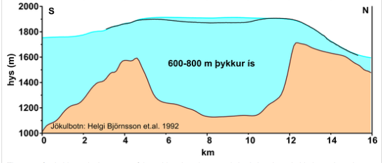
Bárðarbunga is at the center of a 200 km (124 mi) long volcanic system, one of the largest on the planet. The 10 km (6,2 mi) wide caldera is located underneath a 600 to 850-meter (1,968 to 2,788 ft.) thick ice cap in Vatnajökull glacier.
Bárðarbunga is also the second highest mountain in Iceland, measuring 2,009 meters (6,591 ft) above sea level. It was once believed Bárðarbunga, which is a thick ice bulge which rises nearly 1000 m (3,280 ft) above the surrounding landscape was actually the tallest mountain in Iceland.
Hvannadalshnúkur peak in Öræfajökull glacier, another massive volcano in the southern part of Vatnajökull glacier, is actually the tallest peak in Iceland, at 2,110 meters (6,921 ft).

The name of Bárðarbunga translates as The Bulge of Bárður, after Gnúpa Bárður, one of the settlers of Iceland, according to the Book of Settlements. The first people known to have climbed Bárðarbunga were a team of German, Austrian and Italian scientists who climbed the mountain in 1935.
Center of a massive volcanic system
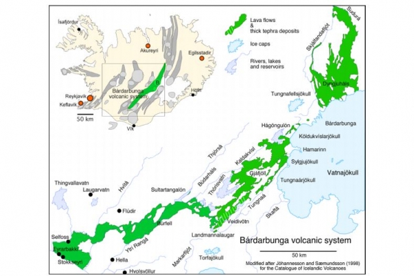
The Bárðarbunga caldera is the center of a larger volcanic system, the largest in Iceland and one of the largest in the world. It has actually produced more lava in the past 10,000 years than any other volcano on Earth. It is composed of a 200 km (124 mi.) long and 25 km (15.5 mi) wide fissure swarm which stretches from the Central Highlands north of Vatnajökull glacier to the Veiðivötn area west of the glacier.
Read more: Video: A group of skiers climb and then descend Hvannadalshnjúkur, the highest peak in Iceland
A second central volcano is located in the Bárðarbunga system, Hamarinn, also known as Loki or Fögrufjöll. Hamarinn is hidden beneath Vatnajökull, to the south-west of Bárðarbunga.
Eruptions in the Bárðarbunga system have frequently taken place in the fissures north and west of Vatnajökull. The last such eruption took place in 2014-2015 along a fissure in the Holuhraun lava field in the Central Highlands north of the glacier.

Current activity began with the Holuhraun eruption
The current seismic episode began following the 2014-2015 Holuhraun eruption. The seismic activity is most likely caused by the re-filling of the magma chambers which were emptied in the Holuhraun eruption.
Read more: See the first photos from inside the burnt out Holuhraun crater
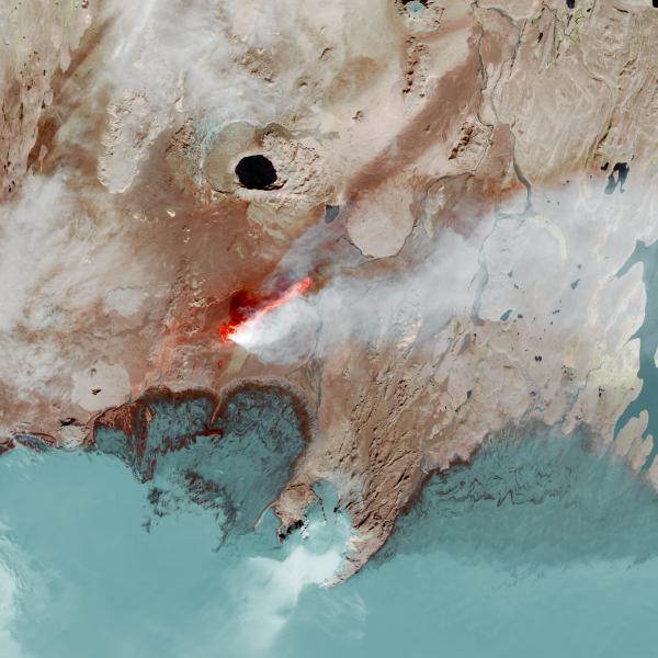
The Holuhraun eruption, which lasted for 181 days (31st August 2014 to 27th February 2015), took place north of the glacier, about 41 km (25.5 mi) north of the caldera, and it left the largest lava field in Iceland since the 1700s. The new lava covers 85 square km (32.8 sq. mi). For scale, imagine an area roughly 1.5 times larger than Manhattan island covered with new 7 to 30 meters (21–90 feet) thick lava.

If you want to see what the lava flow would have looked like in your town or city you can also head over to the interactive Holuhraun Lava Flow website, key in a zip code and then sit back and watch what the eruption would have looked like if it had come up in our own back yard!
Largest eruptions in Icelandic history
One of the reasons scientists keep a close eye on Bárðarbunga is that based on the history of the system, the Holuhraun eruption is likely to be followed by further eruptions. Historically the Bárðarbunga system erupts in drawn-out episodes which include several smaller eruptions, accompanied by intense seismic activity and increased geothermal activity.
Read more: Holuhraun eruption was actually preceded by four sub-glacial eruptions in the Bárðarbunga volcano

The system has erupted on average once every fifty years, with large eruptions every 250 to 600 years. In 1477 the Bárðarbunga system produced the largest known volcanic eruption in Iceland after settlement, and one of the most powerful eruptions in the past 10,000 years in Iceland.
This eruption, which took place in the Veiðivötn region in the western end of the system had a Volcanic Explosive Index, VEI of 6. The VEI index measures the distribution of ash and volcanic materials from an eruption.
No imminent danger of eruption
While Bárðarbunga has been very active since the end of the Holuhraun eruption in 2015, with dozens of large 3+ and 4+ earthquakes, geophysicists at the University of Iceland and the Icelandic Meteorological Office believe there is no imminent threat of an eruption. The IMO continues to monitor its activity closely, as an eruption in Bárðarbunga could pose significant challenges for airline travel in the Northern hemisphere.
Bárðarbunga volcano, hidden beneath the ice cap of Vatnajökull glacier in the Central Highlands, is one of the two largest and most powerful volcanoes in Iceland. Katla, the other, is located beneath Mýrdalsjökull glacier in South Iceland. Both have been showing significant levels of activity seismic activity in the past several months.
Read more: All of Iceland‘s major volcanoes showing unusually high levels of activity
Second highest mountain in Iceland

Bárðarbunga is at the center of a 200 km (124 mi) long volcanic system, one of the largest on the planet. The 10 km (6,2 mi) wide caldera is located underneath a 600 to 850-meter (1,968 to 2,788 ft.) thick ice cap in Vatnajökull glacier.
Bárðarbunga is also the second highest mountain in Iceland, measuring 2,009 meters (6,591 ft) above sea level. It was once believed Bárðarbunga, which is a thick ice bulge which rises nearly 1000 m (3,280 ft) above the surrounding landscape was actually the tallest mountain in Iceland.
Hvannadalshnúkur peak in Öræfajökull glacier, another massive volcano in the southern part of Vatnajökull glacier, is actually the tallest peak in Iceland, at 2,110 meters (6,921 ft).

The name of Bárðarbunga translates as The Bulge of Bárður, after Gnúpa Bárður, one of the settlers of Iceland, according to the Book of Settlements. The first people known to have climbed Bárðarbunga were a team of German, Austrian and Italian scientists who climbed the mountain in 1935.
Center of a massive volcanic system
The Bárðarbunga caldera is the center of a larger volcanic system, the largest in Iceland and one of the largest in the world. It has actually produced more lava in the past 10,000 years than any other volcano on Earth. It is composed of a 200 km (124 mi.) long and 25 km (15.5 mi) wide fissure swarm which stretches from the Central Highlands north of Vatnajökull glacier to the Veiðivötn area west of the glacier.
Read more: Video: A group of skiers climb and then descend Hvannadalshnjúkur, the highest peak in Iceland
A second central volcano is located in the Bárðarbunga system, Hamarinn, also known as Loki or Fögrufjöll. Hamarinn is hidden beneath Vatnajökull, to the south-west of Bárðarbunga.
Eruptions in the Bárðarbunga system have frequently taken place in the fissures north and west of Vatnajökull. The last such eruption took place in 2014-2015 along a fissure in the Holuhraun lava field in the Central Highlands north of the glacier.

Current activity began with the Holuhraun eruption
The current seismic episode began following the 2014-2015 Holuhraun eruption. The seismic activity is most likely caused by the re-filling of the magma chambers which were emptied in the Holuhraun eruption.
Read more: See the first photos from inside the burnt out Holuhraun crater
The Holuhraun eruption, which lasted for 181 days (31st August 2014 to 27th February 2015), took place north of the glacier, about 41 km (25.5 mi) north of the caldera, and it left the largest lava field in Iceland since the 1700s. The new lava covers 85 square km (32.8 sq. mi). For scale, imagine an area roughly 1.5 times larger than Manhattan island covered with new 7 to 30 meters (21–90 feet) thick lava.

If you want to see what the lava flow would have looked like in your town or city you can also head over to the interactive Holuhraun Lava Flow website, key in a zip code and then sit back and watch what the eruption would have looked like if it had come up in our own back yard!
Largest eruptions in Icelandic history
One of the reasons scientists keep a close eye on Bárðarbunga is that based on the history of the system, the Holuhraun eruption is likely to be followed by further eruptions. Historically the Bárðarbunga system erupts in drawn-out episodes which include several smaller eruptions, accompanied by intense seismic activity and increased geothermal activity.
Read more: Holuhraun eruption was actually preceded by four sub-glacial eruptions in the Bárðarbunga volcano

The system has erupted on average once every fifty years, with large eruptions every 250 to 600 years. In 1477 the Bárðarbunga system produced the largest known volcanic eruption in Iceland after settlement, and one of the most powerful eruptions in the past 10,000 years in Iceland.
This eruption, which took place in the Veiðivötn region in the western end of the system had a Volcanic Explosive Index, VEI of 6. The VEI index measures the distribution of ash and volcanic materials from an eruption.
No imminent danger of eruption
While Bárðarbunga has been very active since the end of the Holuhraun eruption in 2015, with dozens of large 3+ and 4+ earthquakes, geophysicists at the University of Iceland and the Icelandic Meteorological Office believe there is no imminent threat of an eruption. The IMO continues to monitor its activity closely, as an eruption in Bárðarbunga could pose significant challenges for airline travel in the Northern hemisphere.


