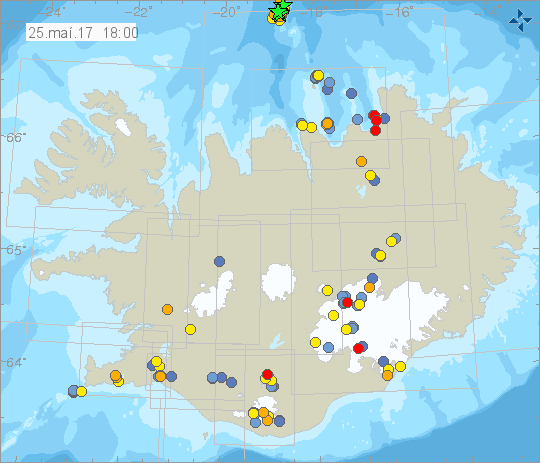
A sharp earthquake swarm was detected north of Kolbeinsey islet yesterday. The area has been showing significant activity in the past couple of days, but at midnight on Thursday a more intense swarm began with a quake which the Icelandic Meteorological Office reports was 3.6 on the Richter scale.
Powerful earthquake swarm shakes Iceland's northernmost point

The islet, which is located 105 km (65 mi) north off the north coast of Iceland and 74 km (46 mi) north-west of Grímsey island, Iceland's northernmost settlement, is the northernmost point of Iceland. It is known to English sailors as Seagull Rock.
Read more: Why the constant earthquakes? Iceland is slowly being torn apart
The first quake was detected at 12 minutes past midnight on Thursday, a 3.6 magnitude quake with an epicenter 14.6 km (90.7 mi) north of Kolbeinsey. Two other powerful quakes were detected the first a 3.6 magnitude quake at 55 minutes past midnight 7.5 km (46,6 mi) north of the islet and a third 3.5 magnitude quake at 7:22 in the morning 10 km (6,2 mi) north of Kolbeinsey. The quakes originated at a depth of 10 km (6,2 mi) below the earth's crust. The IMO reports that the swarm counted at least 116 tremors.
A tiny islet destined to disappear
The islet is located on the Tjörnesbeltið part of the North Atlantic Ridge, a site of intense seismic and volcanic activity. Kolbeinsey is the remnants of a volcanic island which formed in an submarine eruption ca 12,000 years ago. Since then the basalt rock of the islet has been subject to the intense erosion of the North Atlantic.
The original size of the island is unknown, but it would have been significantly larger than it is today. Currently the islet is little more than a skerry, and it is projected to disappear completely within a few years. When the island was first measured in the early 17th century it was 700 m (2,300 ft) from north to south and 100 m (330 ft) east to west. Today it is just 90 sq m (970 sq ft), rising just 8 m above the sea.
A sharp earthquake swarm was detected north of Kolbeinsey islet yesterday. The area has been showing significant activity in the past couple of days, but at midnight on Thursday a more intense swarm began with a quake which the Icelandic Meteorological Office reports was 3.6 on the Richter scale.
Powerful earthquake swarm shakes Iceland's northernmost point

The islet, which is located 105 km (65 mi) north off the north coast of Iceland and 74 km (46 mi) north-west of Grímsey island, Iceland's northernmost settlement, is the northernmost point of Iceland. It is known to English sailors as Seagull Rock.
Read more: Why the constant earthquakes? Iceland is slowly being torn apart
The first quake was detected at 12 minutes past midnight on Thursday, a 3.6 magnitude quake with an epicenter 14.6 km (90.7 mi) north of Kolbeinsey. Two other powerful quakes were detected the first a 3.6 magnitude quake at 55 minutes past midnight 7.5 km (46,6 mi) north of the islet and a third 3.5 magnitude quake at 7:22 in the morning 10 km (6,2 mi) north of Kolbeinsey. The quakes originated at a depth of 10 km (6,2 mi) below the earth's crust. The IMO reports that the swarm counted at least 116 tremors.
A tiny islet destined to disappear
The islet is located on the Tjörnesbeltið part of the North Atlantic Ridge, a site of intense seismic and volcanic activity. Kolbeinsey is the remnants of a volcanic island which formed in an submarine eruption ca 12,000 years ago. Since then the basalt rock of the islet has been subject to the intense erosion of the North Atlantic.
The original size of the island is unknown, but it would have been significantly larger than it is today. Currently the islet is little more than a skerry, and it is projected to disappear completely within a few years. When the island was first measured in the early 17th century it was 700 m (2,300 ft) from north to south and 100 m (330 ft) east to west. Today it is just 90 sq m (970 sq ft), rising just 8 m above the sea.


