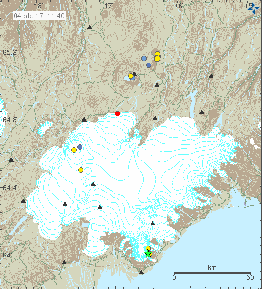
The tallest peak and one of the most dangerous volcanoes in Iceland trembled yesterday, Tuesday as a powerful 3.4 magnitude quake hit Öræfajökull glacier. Earthquakes are rare in Öræfajökull, the southernmost part of Vatnajökull glacier. Öræfajökull towers over South East Iceland, and is easily visible from Skaftafell visitor center in Vatnajökull National Park.
The summit of Öræfajökull is Hvannadalshnjúkur, the tallest peak in Iceland, standing at an elevation of 2,110 meters (6.920 ft).
Volcano kept under close surveillance

The 3.4 magnitude quake was detected at 13:52 on Tuesday. The Icelandic Meteorological Office reports that the epicenter of the quake was at a depth of 2.4 km (1.5 mi), 7 km (4.3 mi) East-South-East of Hvannadalshnjúkur peak. It was felt clearly in the surrounding areas, from Skaftafell visitor center in Vatnajökull National Park to Jökulsárlón glacial lagoon.
Read more: All of Iceland‘s major volcanoes showing unusually high levels of activity
Earthquakes are very rare in Öræfajökull. The last time a large 3+ magnitude quake was detected in the glacier in 2005. A seismologist with the Icelandic Meteorological Office who spoke to the local newspaper Morgunblaðið said that the volcano has been showing signs of growing activity in the volcano. We have detected an elevated level of activity in the volcano, but this could also be a result of better measurement as we have added monitoring equipment.
He stressed that there were no signs of an imminent eruption or danger to civilians. The volcano is kept under close surveillance by the IMO.
A terrifying volcano
Öræfajökull covers a giant volcano which last erupted in 1727. A giant steam-blast eruption, also known as phreatic or ultravolcanian eruption, in 1362 eruption in Öræfajökull was the second deadliest eruption in Icelandic history. One of the best known steam-blast eruptions in history is the 1883 Krakatoa eruption. Steam-blast eruptions occur when magma heats ground water, creating a near-instantaneous evaporation and explosion which can eject enormous quantities of ash, rock and volcanic material which is then deposited over surrounding areas.
Read more: Why the constant earthquakes? Iceland is slowly being torn apart
The 1362 Öræfajökull eruption destroyed one of the most prosperous farmland regions in South Iceland, killing all inhabitants and livestock at 20-40 farms in a region which was known then as Litla-hérað. Following the eruption, which deposited 10 cubic kilometers of volcanic material over fields and farms in the region, it's name changed to Öræfi, which translates as Wasteland in modern Icelandic.
The volcano is not particularly active, erupting at an interval of several hundred years. The 1362 eruption is considered to be the largest tepthra eruption in the world in the last 1000 years. The last eruption in 1727-28 was far smaller and caused only three fatalities.
The tallest peak and one of the most dangerous volcanoes in Iceland trembled yesterday, Tuesday as a powerful 3.4 magnitude quake hit Öræfajökull glacier. Earthquakes are rare in Öræfajökull, the southernmost part of Vatnajökull glacier. Öræfajökull towers over South East Iceland, and is easily visible from Skaftafell visitor center in Vatnajökull National Park.
The summit of Öræfajökull is Hvannadalshnjúkur, the tallest peak in Iceland, standing at an elevation of 2,110 meters (6.920 ft).
Volcano kept under close surveillance

The 3.4 magnitude quake was detected at 13:52 on Tuesday. The Icelandic Meteorological Office reports that the epicenter of the quake was at a depth of 2.4 km (1.5 mi), 7 km (4.3 mi) East-South-East of Hvannadalshnjúkur peak. It was felt clearly in the surrounding areas, from Skaftafell visitor center in Vatnajökull National Park to Jökulsárlón glacial lagoon.
Read more: All of Iceland‘s major volcanoes showing unusually high levels of activity
Earthquakes are very rare in Öræfajökull. The last time a large 3+ magnitude quake was detected in the glacier in 2005. A seismologist with the Icelandic Meteorological Office who spoke to the local newspaper Morgunblaðið said that the volcano has been showing signs of growing activity in the volcano. We have detected an elevated level of activity in the volcano, but this could also be a result of better measurement as we have added monitoring equipment.
He stressed that there were no signs of an imminent eruption or danger to civilians. The volcano is kept under close surveillance by the IMO.
A terrifying volcano
Öræfajökull covers a giant volcano which last erupted in 1727. A giant steam-blast eruption, also known as phreatic or ultravolcanian eruption, in 1362 eruption in Öræfajökull was the second deadliest eruption in Icelandic history. One of the best known steam-blast eruptions in history is the 1883 Krakatoa eruption. Steam-blast eruptions occur when magma heats ground water, creating a near-instantaneous evaporation and explosion which can eject enormous quantities of ash, rock and volcanic material which is then deposited over surrounding areas.
Read more: Why the constant earthquakes? Iceland is slowly being torn apart
The 1362 Öræfajökull eruption destroyed one of the most prosperous farmland regions in South Iceland, killing all inhabitants and livestock at 20-40 farms in a region which was known then as Litla-hérað. Following the eruption, which deposited 10 cubic kilometers of volcanic material over fields and farms in the region, it's name changed to Öræfi, which translates as Wasteland in modern Icelandic.
The volcano is not particularly active, erupting at an interval of several hundred years. The 1362 eruption is considered to be the largest tepthra eruption in the world in the last 1000 years. The last eruption in 1727-28 was far smaller and caused only three fatalities.


