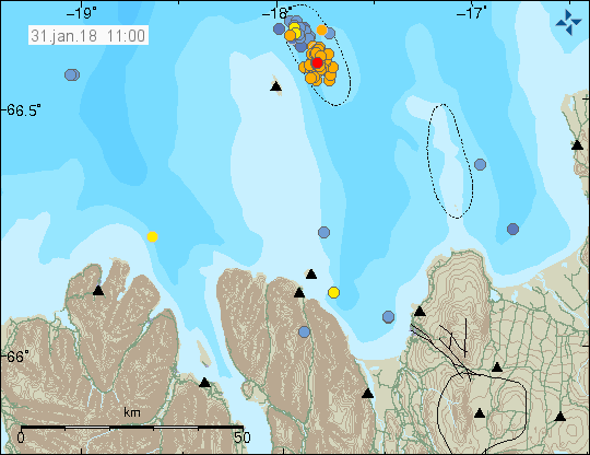
The earthquake swarm which hit Grímsey Island over the weekend continued with an intense episode after midnight. More than a hundred small quakes continued to shake the island until early morning. Grímsey Island, which straddles the Arctic Circle, is the northernmost settlement in Iceland, home to 90 inhabitants.
Read more: Sharp earthquake swarm near Grímsey island, northernmost settlement in Iceland
The current episode began on Saturday morning with a sharp 4.1 magnitude quake. A second 3.4 magnitude quake hit shortly thereafter, followed by more than 170 separate tremors. Since then the island has experienced a few smaller swarms, the largest hitting this morning.
Read more: Why the constant earthquakes? Iceland is slowly being torn apart
No volcanic activity expected

At the same time as Grímsey has trembled Bárðarbunga, one of the most powerful volcanic systems in Iceland, has also seen significant levels of activity. However, an expert at the Icelandic Meteorological Office told the local newspaper Morgunblaðið that there were no signs that the seismic episodes signaled imminent volcanic activity.
Read more: Bárðarbunga continues to tremble: Most powerful quake since end of 2015 eruption
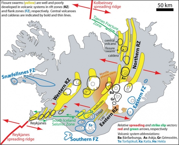
The quakes have all been along the Tjörnesbrotabelti, or Tjörnes rift zone. The Tjörnes rift zone is part of the North Atlantic Ridge, where the North American and Euroasian tectonic plates drift in opposite directions. The area known for high geological activity, including geothermal and volcanic activity. The Tjörnes fracture zone is also a source of regular and significant seismic activity, caused by energy being released as the tectonic plates drift in opposite directions from one another.
Grímsey itself is a small island with a surface area of the island is just 5.3 km2 (2 sq miles), located 40 km (25 miles) off the north coast of Iceland. The island has a population of some 90 people.

The earthquake swarm which hit Grímsey Island over the weekend continued with an intense episode after midnight. More than a hundred small quakes continued to shake the island until early morning. Grímsey Island, which straddles the Arctic Circle, is the northernmost settlement in Iceland, home to 90 inhabitants.
Read more: Sharp earthquake swarm near Grímsey island, northernmost settlement in Iceland
The current episode began on Saturday morning with a sharp 4.1 magnitude quake. A second 3.4 magnitude quake hit shortly thereafter, followed by more than 170 separate tremors. Since then the island has experienced a few smaller swarms, the largest hitting this morning.
Read more: Why the constant earthquakes? Iceland is slowly being torn apart
No volcanic activity expected

At the same time as Grímsey has trembled Bárðarbunga, one of the most powerful volcanic systems in Iceland, has also seen significant levels of activity. However, an expert at the Icelandic Meteorological Office told the local newspaper Morgunblaðið that there were no signs that the seismic episodes signaled imminent volcanic activity.
Read more: Bárðarbunga continues to tremble: Most powerful quake since end of 2015 eruption
The quakes have all been along the Tjörnesbrotabelti, or Tjörnes rift zone. The Tjörnes rift zone is part of the North Atlantic Ridge, where the North American and Euroasian tectonic plates drift in opposite directions. The area known for high geological activity, including geothermal and volcanic activity. The Tjörnes fracture zone is also a source of regular and significant seismic activity, caused by energy being released as the tectonic plates drift in opposite directions from one another.
Grímsey itself is a small island with a surface area of the island is just 5.3 km2 (2 sq miles), located 40 km (25 miles) off the north coast of Iceland. The island has a population of some 90 people.


