The seismic activity off the north coast of Iceland which began on Wednesday last week is still ongoing, although the intensity of the quakes appears to have slowed down somewhat. No 3+ quakes have been detected since early morning today, Tuesday. However, it is still too early to say whether the activity is dying out or whether the Tjörnes fracture system, is just catching its breath before the next big thing.
Read more: Grímsey watch: 60 powerful 3+ earthquakes hit yesterday, hundreds of smaller tremors
Area known for high levels of geological activity
The area where the seismic episode has taken place is part of the Tjörnes fracture zone, an area known for high levels of seismic, geothermal and volcanic activity. The majority of the major quakes in the swarm have taken place in and around a range of submarine volcanoes, part of the Nafir volcanic system which is located in a submarine rift valley called Skjálfandadjúp. The rift valley and the Nafir system are part of the Tjörnes fracture zone.

Geophysicists believe the tremors are the result of fissure rifting caused by the drifting of the tectonic plates. The North American and Eurasian tectonic plates drift in opposite directions from one another in the Tjörnes fracture zone by dragging along each other, rather than drifting in opposite directions as they do on the Kolbeinsey spreading ridge to the north of the Tjörnes fracture zone.
Fissure rifting event
Fissure rifting events can easily trigger bigger earthquakes in different parts of the fissure system. Ragnar Stefánsson, a seismologist with the IMO told the local newspaper Morgunblaðið that scientists have been expecting a 6.5 magintude quake in the Tjörnes system for some time. The largest known earthquake in the Tjörnes fracture zone was a 7+ quake which was detected south of Grímsey in 1910.
Read more: Intense earthquakes in Grímsey highly unusual. Volcanic eruption unlikely
Ragnar told Morgunblaðið that it appeared that the magma movements associated with the quakes have been at too great depths to be associated with rising likelihood of eruptions. They could, however, change geothermal activity in the region.
Eruption cannot be ruled out
However, an eruption cannot be ruled out completely, as little is known about the behavior or eruption history of the submarine volcanoes off the coast of Iceland.

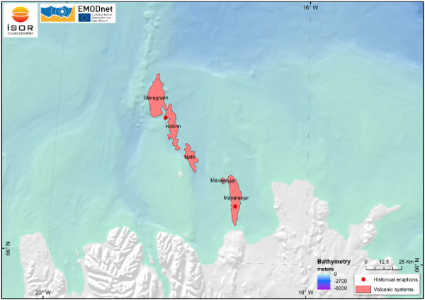
The Tjörnes fracture zone includes four different volcanic systems: The southernmost is the Mánáreyjar system, which erupted in 1867. The Nafir system is northeast of Grímsey. North of Nafir is Hóllinn, which is known to have erupted in 1372. The northernmost system is Stóragrunn, which is also the largest submarine volcano in the region. Although only two eruptions are known from historical records scientists believe the systems have produced a number of other eruptions which were not detected, as they took place on the ocean floor.
Recent lava has been found on the ocean floor north of Grímsey, suggesting more frequent eruptions. In a large study which took place in 2001-2005, produced evidence that a previously unknown eruption took place in Stóragrunn sometime in the 20th century. A geophysicist who spoke to the local TV station Stöð 2 said submarine eruptions are probably quite common in the area.
An active volcanic range
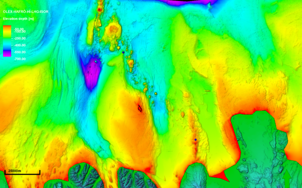
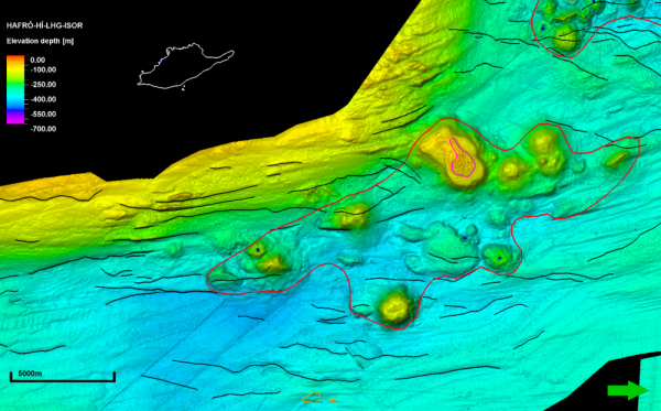
Scientists at Iceland Geosurvey, ÍSOR, have also cautioned that it's too early to rule out a volcanic event. ÍSOR has compiled a very detailed map of the ocean floor north of Iceland, mapping geothermal and volcanic systems. One of the systems which ÍSOR has mapped extensively is the Nafir system north east of Grímsey.
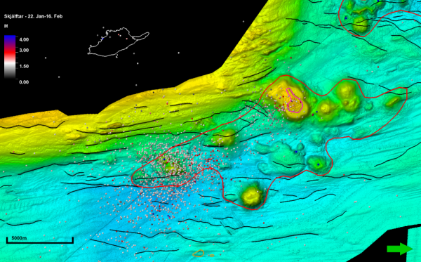
ÍSOR stresses that the seismic measurements gathered by the IMO are incomplete. With the exception of the seismic monitoring station in Grímsey all measuring stations are located on the Icelandic mainland, to the south of the activity. This increases the uncertainty in the measurements. However, the measurements do show that the quakes have been concentrated at a depth of more than 5 km (3 mi) beneath the southernmost volcano in the Nafir system.
This, they argue, suggest some kind of movements connected to magma being thrust into the rock beneath the volcano. Whether such movements will lead to an eruption is a different story, they admit, as recent experience has shown that significant magma movements can take place without a volcanic event.

The seismic activity off the north coast of Iceland which began on Wednesday last week is still ongoing, although the intensity of the quakes appears to have slowed down somewhat. No 3+ quakes have been detected since early morning today, Tuesday. However, it is still too early to say whether the activity is dying out or whether the Tjörnes fracture system, is just catching its breath before the next big thing.
Read more: Grímsey watch: 60 powerful 3+ earthquakes hit yesterday, hundreds of smaller tremors
Area known for high levels of geological activity
The area where the seismic episode has taken place is part of the Tjörnes fracture zone, an area known for high levels of seismic, geothermal and volcanic activity. The majority of the major quakes in the swarm have taken place in and around a range of submarine volcanoes, part of the Nafir volcanic system which is located in a submarine rift valley called Skjálfandadjúp. The rift valley and the Nafir system are part of the Tjörnes fracture zone.

Geophysicists believe the tremors are the result of fissure rifting caused by the drifting of the tectonic plates. The North American and Eurasian tectonic plates drift in opposite directions from one another in the Tjörnes fracture zone by dragging along each other, rather than drifting in opposite directions as they do on the Kolbeinsey spreading ridge to the north of the Tjörnes fracture zone.
Fissure rifting event
Fissure rifting events can easily trigger bigger earthquakes in different parts of the fissure system. Ragnar Stefánsson, a seismologist with the IMO told the local newspaper Morgunblaðið that scientists have been expecting a 6.5 magintude quake in the Tjörnes system for some time. The largest known earthquake in the Tjörnes fracture zone was a 7+ quake which was detected south of Grímsey in 1910.
Read more: Intense earthquakes in Grímsey highly unusual. Volcanic eruption unlikely
Ragnar told Morgunblaðið that it appeared that the magma movements associated with the quakes have been at too great depths to be associated with rising likelihood of eruptions. They could, however, change geothermal activity in the region.
Eruption cannot be ruled out
However, an eruption cannot be ruled out completely, as little is known about the behavior or eruption history of the submarine volcanoes off the coast of Iceland.

The Tjörnes fracture zone includes four different volcanic systems: The southernmost is the Mánáreyjar system, which erupted in 1867. The Nafir system is northeast of Grímsey. North of Nafir is Hóllinn, which is known to have erupted in 1372. The northernmost system is Stóragrunn, which is also the largest submarine volcano in the region. Although only two eruptions are known from historical records scientists believe the systems have produced a number of other eruptions which were not detected, as they took place on the ocean floor.
Recent lava has been found on the ocean floor north of Grímsey, suggesting more frequent eruptions. In a large study which took place in 2001-2005, produced evidence that a previously unknown eruption took place in Stóragrunn sometime in the 20th century. A geophysicist who spoke to the local TV station Stöð 2 said submarine eruptions are probably quite common in the area.
An active volcanic range
Scientists at Iceland Geosurvey, ÍSOR, have also cautioned that it's too early to rule out a volcanic event. ÍSOR has compiled a very detailed map of the ocean floor north of Iceland, mapping geothermal and volcanic systems. One of the systems which ÍSOR has mapped extensively is the Nafir system north east of Grímsey.
ÍSOR stresses that the seismic measurements gathered by the IMO are incomplete. With the exception of the seismic monitoring station in Grímsey all measuring stations are located on the Icelandic mainland, to the south of the activity. This increases the uncertainty in the measurements. However, the measurements do show that the quakes have been concentrated at a depth of more than 5 km (3 mi) beneath the southernmost volcano in the Nafir system.
This, they argue, suggest some kind of movements connected to magma being thrust into the rock beneath the volcano. Whether such movements will lead to an eruption is a different story, they admit, as recent experience has shown that significant magma movements can take place without a volcanic event.


