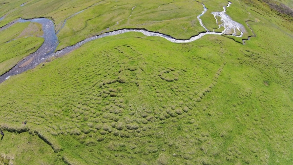
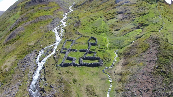
Archaeologists working for the History and Heritage Museum of Skagafjörður have been using drones to chart archaeological sites in Skagafjörður fjord. According to Guðný Zoëga, the chief archaeologist at the museum, the drones provide a unique view of research sites, allowing archaeologist to spot remains which they could not see from the ground.
Currently Guðný and archaeologists working for the History and Heritage Museum are focusing on areas far from present settlement, including inland valleys and heaths. The goal is to chart the extent of human settlement in Skagafjörður through the centuries.

Written sources contain records of six hundred farms in Skagafjörður, but research by archaeologists suggests that a far larger number of farms have been inhabited at some time. According to archaeologist Guðný Zoëga, the total number of farms which have been occupied at one time or another since settlement in Skagafjörður exceeds one thousand.

Guðný tells Iceland Insider that the research has revealed that human settlement in Skagafjörður reached very deep into inland valleys and far from sea relatively quickly after the settlement of Iceland according to written sources. „Already during the Viking Age, in the 10th and 11th centuries many farms were being constructed deep in inland valleys and high above sea level, 300-400 meters (660-1300 feet) above sea level“. At the same time the research shows a very dynamic settlement pattern, as many of these early farms were abandoned in the first centuries of Icelandic history.
Archaeologists working for the History and Heritage Museum of Skagafjörður have been using drones to chart archaeological sites in Skagafjörður fjord. According to Guðný Zoëga, the chief archaeologist at the museum, the drones provide a unique view of research sites, allowing archaeologist to spot remains which they could not see from the ground.
Currently Guðný and archaeologists working for the History and Heritage Museum are focusing on areas far from present settlement, including inland valleys and heaths. The goal is to chart the extent of human settlement in Skagafjörður through the centuries.

Written sources contain records of six hundred farms in Skagafjörður, but research by archaeologists suggests that a far larger number of farms have been inhabited at some time. According to archaeologist Guðný Zoëga, the total number of farms which have been occupied at one time or another since settlement in Skagafjörður exceeds one thousand.

Guðný tells Iceland Insider that the research has revealed that human settlement in Skagafjörður reached very deep into inland valleys and far from sea relatively quickly after the settlement of Iceland according to written sources. „Already during the Viking Age, in the 10th and 11th centuries many farms were being constructed deep in inland valleys and high above sea level, 300-400 meters (660-1300 feet) above sea level“. At the same time the research shows a very dynamic settlement pattern, as many of these early farms were abandoned in the first centuries of Icelandic history.


