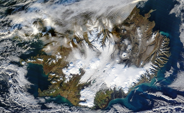

One of our favourite sites on the Internet, NASA's Earth Observatory page, has just published a fantastic satellite image of Iceland. The natural-colour photo was captured on 9th of November and has many interesting sides to it.
You can see how the snow cover, that blankets the central interior in the winter months, is starting to spread. As Earth Observatory’s experts point out Iceland’s permanent ice caps appear smooth and rounded in the image, in contrast with the snow-covered interior plateau or the snow-capped ridges along the glacier-carved coastline.
Glaciers cover around 11% of Iceland’s 103.000 km2 (39.768 sq. mi. – roughly the same size as the state of Kentucky in the USA).
As Earth Observatory’s experts notice Iceland’s glaciers have been retreating rapidly and losing volume for years, but as we have previously reported scientists from the Icelandic Met Office (IMO) have now recorded that one of the glaciers, Hofsjökull (outlined in red in the image), has gained mass for the first time in 21 years.

Hofsjökull is Iceland’s third largest glacier, covering 925 km2 (357 sq. mi), and is the home to a huge dormant volcano. The glacier is the source of Iceland’s longest river, Þjórsá, and several other rivers.
In an interview with the Earth Observatory, IMO glaciologist Þorsteinn Þorsteinsson explains that Hofsjökull’s reversal in 2015 is due to abundant winter precipitation and cool summer temperatures.
Several lakes and reservoirs are clearly visible as dark spots in the image and three have been marked with their names.
The most interesting dark spot is however, Holuhraun, the new lava field that was formed in the central highlands in an eruption that lasted from August 2014 to February 2015. The eruption was in an ice free zone about 5 km (3 mi) north of Vatnajökull glacier and left a new lava field spreading over 85 km2 (32.8 sq. mi). For scale, imagine an area roughly 1.5 times larger than Manhattan island covered with new 7 to 30 meters (21–90 feet) thick lava.