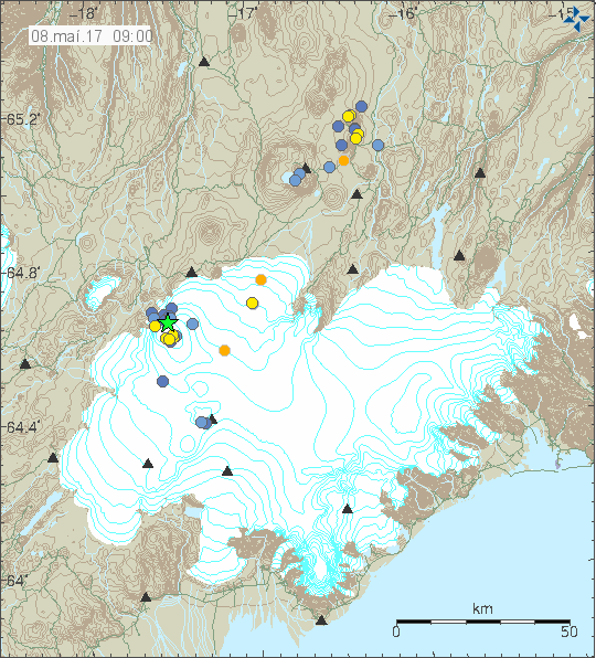
The 4.5 magnitude earthquake west of volcano Hekla on Saturday was followed up by a 3.2 magnitude quake in the Bárðarbunga caldera later the same evening. The quake, which had its epicenter at a depth of 4.3 km (2.7 miles) in the N.E. part of the caldera was followed by a swarm of smaller quakes, including two 2.1 and 2.5 magnitude quakes, in the N.E. and S.E parts of the caldera.
Read more: Powerful 4.5 magnitude earthquake west of volcano Hekla in South Iceland
What is going on?
It is unlikely the two episodes are connected. The earthquakes in Bárðarbunga are caused by magma thrusting its way from the mantle to the magma chambers of the volcano, refilling it after the 2014-15 Holuhraun eruption. Bárðarbunga is preparing for continued volcanic activity.

The Saturday quake west of Hekla took place in the South Iceland Seismic Zone, a transform fault between offset sections of the Mid-Atlantic Ridge which runs through Iceland. The zone is made up of a series of fracture faults which run from SW to NE. The zone extends from the volcano Hengill, the easternmost part of the Reykjanes volcanic zone to Hekla, which is the westernmost volcano in the East Volcanic Zone.
The massive South Iceland Quake
There are no active volcanoes in the South Iceland Seismic Zone, but it is extremely active. The area sits between the two volcanic zones, and is constantly being pulled in two different directions, causing tension to build up in the crust which is then periodically released in earthquakes.
The zone has been the source of the most powerful earthquakes in Iceland, as the most powerful earthquake which has taken place in Iceland since the country was settled took place in the Southern Seismic Zone.

Read more: All of Iceland‘s major volcanoes showing unusually high levels of activity
On 1784 a massive earthquake, which is believed to have been 7.1 magnitude, shook all of southern Iceland, causing widespread damage to farmhouses.
The second largest earthquake, and the largest to be measured with modern equipment, was detected in 1912. This quake was 7.0 on the Richter scale. Both quakes took place close to Saturday's tremor. Quakes of this magnitude are believed to hit once every 100-150 years, and could cause significant damage. Locals in South Iceland are still waiting for the big one.
The 4.5 magnitude earthquake west of volcano Hekla on Saturday was followed up by a 3.2 magnitude quake in the Bárðarbunga caldera later the same evening. The quake, which had its epicenter at a depth of 4.3 km (2.7 miles) in the N.E. part of the caldera was followed by a swarm of smaller quakes, including two 2.1 and 2.5 magnitude quakes, in the N.E. and S.E parts of the caldera.
Read more: Powerful 4.5 magnitude earthquake west of volcano Hekla in South Iceland
What is going on?
It is unlikely the two episodes are connected. The earthquakes in Bárðarbunga are caused by magma thrusting its way from the mantle to the magma chambers of the volcano, refilling it after the 2014-15 Holuhraun eruption. Bárðarbunga is preparing for continued volcanic activity.

The Saturday quake west of Hekla took place in the South Iceland Seismic Zone, a transform fault between offset sections of the Mid-Atlantic Ridge which runs through Iceland. The zone is made up of a series of fracture faults which run from SW to NE. The zone extends from the volcano Hengill, the easternmost part of the Reykjanes volcanic zone to Hekla, which is the westernmost volcano in the East Volcanic Zone.
The massive South Iceland Quake
There are no active volcanoes in the South Iceland Seismic Zone, but it is extremely active. The area sits between the two volcanic zones, and is constantly being pulled in two different directions, causing tension to build up in the crust which is then periodically released in earthquakes.
The zone has been the source of the most powerful earthquakes in Iceland, as the most powerful earthquake which has taken place in Iceland since the country was settled took place in the Southern Seismic Zone.

Read more: All of Iceland‘s major volcanoes showing unusually high levels of activity
On 1784 a massive earthquake, which is believed to have been 7.1 magnitude, shook all of southern Iceland, causing widespread damage to farmhouses.
The second largest earthquake, and the largest to be measured with modern equipment, was detected in 1912. This quake was 7.0 on the Richter scale. Both quakes took place close to Saturday's tremor. Quakes of this magnitude are believed to hit once every 100-150 years, and could cause significant damage. Locals in South Iceland are still waiting for the big one.


