One of the things all visitors to Reykjavík notice is that it's a young city. Reykjavík was only is a young city.
While the first permanent settler in Iceland, Ingólfur Arnarson, decided to set up his farm in Reykjavík, the settlement remained little more than a few farms. In the middle ages several farms were established on the Reykjavík peninsula (which is actually called Seltjarnarnes peninsula), as well as on the islands off the coast.
It was only in the 1700s that a small village formed in Reykjavík, clustered around Aðalstræti street in downtown Reykjavík. As Iceland industrialized around the turn of the century 1900 this small village quickly became the center of the new trawling industry, expanding beyond the narrow strip of land between the harbour and the downtown pond, toward the west, along the harbour and to the west up the slopes of Skólavörðuholt hill. Hallgrímskirkja now stands at the top of this hill.
Read more: Watch: What did the “bleak outpost” of Reykjavík look like in WWII?
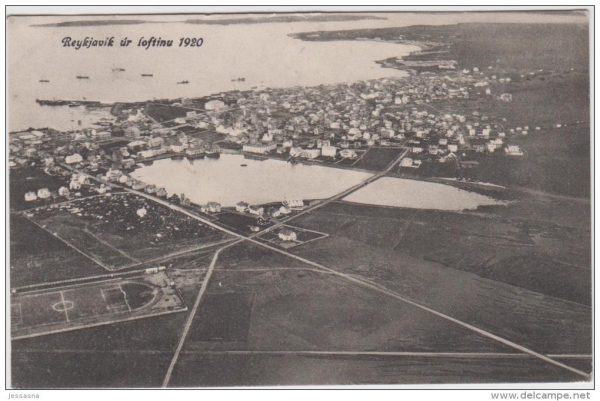
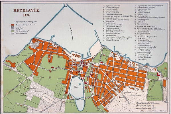
But as the map above shows, Reykjavík was still a very small town in 1920! To help you navigate the map, the aerial photo below, allows you to identify some of the landmarks and buildings, several of which stand today. The city has changed dramatically!

One of the things one notices immediately is the transformation of the harbour area which has been expanded dramatically with landfills. The Grandi area, on the western edge of the harbour, is nothing more than a narrow isthmus connecting the island Örfirisey to the mainland.

One of the things all visitors to Reykjavík notice is that it's a young city. Reykjavík was only is a young city.
While the first permanent settler in Iceland, Ingólfur Arnarson, decided to set up his farm in Reykjavík, the settlement remained little more than a few farms. In the middle ages several farms were established on the Reykjavík peninsula (which is actually called Seltjarnarnes peninsula), as well as on the islands off the coast.
It was only in the 1700s that a small village formed in Reykjavík, clustered around Aðalstræti street in downtown Reykjavík. As Iceland industrialized around the turn of the century 1900 this small village quickly became the center of the new trawling industry, expanding beyond the narrow strip of land between the harbour and the downtown pond, toward the west, along the harbour and to the west up the slopes of Skólavörðuholt hill. Hallgrímskirkja now stands at the top of this hill.
Read more: Watch: What did the “bleak outpost” of Reykjavík look like in WWII?
But as the map above shows, Reykjavík was still a very small town in 1920! To help you navigate the map, the aerial photo below, allows you to identify some of the landmarks and buildings, several of which stand today. The city has changed dramatically!

One of the things one notices immediately is the transformation of the harbour area which has been expanded dramatically with landfills. The Grandi area, on the western edge of the harbour, is nothing more than a narrow isthmus connecting the island Örfirisey to the mainland.


